Situation
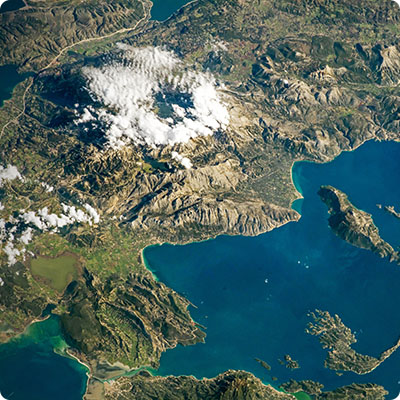
Borneo straddles the equator, at the intersection of the Pacific and Indian Oceans. Insulinde's largest island is surrounded by four seas: the China Sea to the northwest, the Sulu Sea to the north, the Celebes Sea to the east and the Java Sea to the west, as well as the Strait of Macassar to the southeast. Including the adjacent islands, Borneo has a total surface area of 755,000 km2. According to 2024 estimates, there are just over 17 million inhabitants in the five provinces of Kalimantan. Sabah has a population of 3.6 million and Sarawak 2.45 million (6.1 million in the Malaysian part of the island). Brunei is home to a population of 455,850, which is relatively large given the sultanate's small size.
Relief
Borneo, along with Bali, Java and Sumatra, was part of the Asian continent before the end of the Quaternary ice ages and the rise of the sea. This peninsula extended to the south-east of Vietnam. Today, these islands form the visible part of the Sunda Shelf, a submerged extension of the continent. Most of the island is mountainous, while the rest is made up of vast plains, particularly in Sarawak and Central Kalimantan. These plains are home to lush equatorial forests, alluvial plains and swampy areas along the coast. Several mountain ranges, stretching from the southeast to the northwest of the island, form Borneo's central spine. The Müller Range (Pegunungan Muller) in Kalimantan and the Crocker Range (Banjaran Crocker) in Sabah are among the most important. Mount Kinabalu, which lies in the Crocker Range at the northeastern tip of the island, is the highest point in Borneo and the highest peak in Malaysia, at 4,095 meters. Its main peak, Low's Peak, used to have an estimated altitude of 4,101 metres, but a new, more accurate satellite survey in 1997 reduced its official height by 6 metres. Mount Kinabalu is a UNESCO World Heritage Site and features on the flag of the state of Sabah. The island's other highest peaks are Mount Trusmadi in Sabah (2,642 m), Bukit Raya in Kalimantan Tengah (2,278 m), followed by Gunung Muruk Miau (2,084 m) and Gunung Wakid (2,066 m) in Sabah. Although the island is surrounded by an active volcanic belt, Borneo has no active or extinct volcanoes.
Caves
The island boasts an extensive network of caves. In Sarawak, the cave system of Gunung Mulu National Park comprises hundreds of kilometers of underground galleries, with countless tunnels and chambers. The world's longest underground river can also be found in Clearwater Cave. More than three million bats call Deer Cave home, with its 146-metre-high entrance! The caves were first explored in 1978, and in 2010 an expedition uncovered a further 350 km of galleries. It is estimated that only 30% of this cave system has been explored to date. The twenty or so limestone caves of Gomantong lie in the heart of a lush forest, not far from the town of Sandakan, in Sabah's Kinabatangan sanctuary. They are famous for providing a habitat for swallows, whose nests are a particularly sought-after delicacy in Southeast Asia for their many medicinal virtues. The caves of Agup Batu Tulung, in the Kinabatangan region, are set in steep limestone cliffs. An important archaeological site, the caves are home to some 100 ancient burial sites. In Kalimantan Timur, the Sangkulirang-Mangkalihat karst is a karst region containing thousands of caves where ancient bones of extinct animals have been found. Among these caves is the Lubang Jeriji Saléh limestone cave complex, home to hundreds of ochre-coloured hand outlines dating back over 52,000 years. This archaeological site is also home to interesting figurative rock paintings dating back some 40,000 years. A 1.5 m mural depicting a banteng (or tembadau), a small wild ox from Southeast Asia, is the site's most emblematic representation.
Hydrography
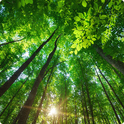
Water is omnipresent in Borneo: the island is surrounded by four seas, covered by equatorial rainforest over most of its territory and subject to heavy rainfall all year round. In addition, Borneo is largely drained by rivers and streams that radiate from the central highlands and flow into deltas along the coast, forming a vast network of waterways that are often the only access routes to certain regions. These waterways are essential for trade, and vital for the inhabitants of the many villages that have sprung up along their banks. The most important rivers are located in Kalimantan, the Indonesian part of the island. The Sungai Kapuas, in Kalimantan Barat, is Borneo's largest river in terms of length and flow. It rises on the Sarawak border and flows 1,143 km into the South China Sea, near Pontianak. The Kapuas is the main waterway in the west of the island, and is used by loggers to transport timber inland. At 1,090 km long, the Barito is Borneo's second most important river, flowing through Kalimantan Sengah. It rises in the Müller mountain range and flows south into the Java Sea. Its most important tributary is the Martapura River. To the east of the island, the Mahakam River flows through Kalimantan Timur and is the third longest river on the island (980 km). The main river in the Malaysian part of the island, the Rajang, is located in Sarawak. With a total length of 564 km, it is also the longest river in Malaysia. Sabah's most important river is the Sungai Kinabatangan, which rises in the Crocker Range and flows into the Sulu Sea. It is 560 km long and has a catchment area of 16,800 km2, covering almost 23% of the state's territory.