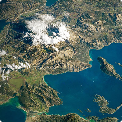
A living relief
Essentially made up of plateaus and mountains, Cameroon's current relief owes its structure to the volcanic upheavals that took place during the Tertiary Era (end of the Cretaceous, i.e. -65 million years ago). Today, the south-western part of the country is covered by a massif that follows a south-western/north-eastern ridge punctuated by volcanic peaks. This line begins on the island of Bioko, off the coast of Douala, and continues on the mainland with Mount Cameroon, which reaches an altitude of 4,090 m. The country's highest peak, Mount Cameroon is a volcano that erupts regularly (April 1999, March 2000, most recently in February 2012), with a periodicity estimated at around fifteen years. Its eruptions, which are not very explosive, are of a Hawaiian or Strombolian nature, and result in volcanic fissures emitting lava flows, the last of which spread over some 300 metres of Mount Cameroun's slopes, devastating the surrounding plantations and palm groves.
Mount Cameroun is located very close to the coast, and for good reason: it was originally on an island. Then there's Mount Koupé (2,011 m), which straddles the former border between French-speaking and English-speaking Cameroon. Mount Koupé is a volcano surrounded by secondary peaks, and its steep slopes are covered by virgin cloud forest (a rainforest typical of high-altitude tropical areas), which gradually gives way to grassland as you climb.
Nearby Mont Manengouba rises to an altitude of around 2,400 metres. An ancient volcano, it is surrounded by tropical forest. It is home to two crater lakes known as the twin lakes: Lac mâle and Lac femelle, bounded by a thin ridge.
The Bamboutos Mountains (2,700 m) are located between the towns of Bafoussam and Bamenda, dividing the West and North-West regions.
Towards the north-east of the country, this mountain range continues with the Adamaoua massif, a region of high plateaus reaching altitudes of up to 2,500 meters. The geological features of this region are similar to those of the volcanic massifs of the central Sahara, such as the Hoggar in southern Algeria. Although the Adamaoua landscapes are more heavily watered than those of Algeria, they are still characterized by steep granite cliffs, commonly referred to as "sugar loafs". The surrounding landscape is dominated by high-altitude pastures.
Plains and high plateaus
To the north of Adamaoua and as far as Lake Chad lies a medium-altitude plain, dominated by a savannah landscape that reminds us of the nearby Sahel. There are, however, two exceptions to this dry landscape. The first is the Bénoué valley (also known as the Bénoué basin). This river, a major tributary of the Niger River, caresses the Garoua region from west to east. Then there are the Mandara Mountains, located to the west of Maroua. Over 150 km long, they form a natural border between Cameroon to the east and Nigeria to the west. The landscape is made up of high plateaus and peaks surrounded by grasslands, reminiscent of the Adamaoua region.
To the south of Adamaoua and in a large south-eastern part of Cameroon, we find the central region, with its medium-altitude plains and landscapes turned towards equatorial Africa, with large areas of swamps and tropical forests. The vegetation is dense and humidity levels are often close to 90%. This part of the country is crossed by the Sanaga, one of Cameroon's main rivers, which rises in the Adamaoua region. The landscape here is green and hilly.
Finally, in the south-west of the country, the coastal plain is dominated by Mount Cameroon and the mouths of two rivers: a vast estuary for the Wouri, at the foot of Mount Cameroon, and a delta for the Sanaga, which flows into the sea further south. The South-West region combines sea and mountains, black sand coastlines and volcanoes.
A landscape shaped by water
These varied reliefs, the result of a complex geological history, have also been subjected to the assaults of numerous rivers and streams, which have carved out patterns such as peaks, domes and rocky outcrops, with waterfalls and rapids that are often spectacular. The flow of these rivers is often highly irregular (particularly in the north), with high water levels during the rainy season.
These variations make it difficult to use them for river traffic, but the water represents an interesting resource for hydroelectric production, justifying the construction of several dams (as at Edéa, on the road from Douala to Yaoundé, Song-Loulou still near Edéa, Lagdo in the north of the country, Mbakaou, Koloza, etc.).
If water has created specific landforms, Cameroon's different landforms have, in turn, imposed several distinct river basins. The most important of these is the one that empties into the Atlantic Ocean in the southwest of the country, with rivers such as the Nyong, Wouri and Sanaga.
In the north of the country, rivers flow into Lake Chad, in particular the Logone, which marks the border between Chad and Cameroon. This leaves two final basins controlled by the gigantic rivers of neighbouring countries: the Ngoko, which flows from the Congo River, and the Bénoué to the west, which flows from the Niger River.
With its many lakes, waterfalls and rivers, its sometimes torrential rainfall, but also its volcanic mountain ranges, far from completely dormant as Mount Cameroon showed less than ten years ago, its arid regions bordering the Sahel in the north and its large bush fires, Cameroon is truly a land of contrasts, where fires and torrents cohabit. Sea and mountains, plains and forests, rivers and drought, it's around these contrasts that we discover this country, which reveals itself through a certain complexity that is not unworthy of interest. A well-informed traveller will not be surprised by the dampness of the tropical forests, the coolness of the mountains and high plateaus, or even by the scorching sun and dusty winds from the Sahara. Discovering Cameroon means knowing how to adapt and cope with varied travel conditions, and letting yourself be amazed by living, constantly-changing landscapes.