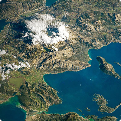
The Seine flows through the south of the region
It runs alongside three communes in the Val Parisis conurbation: Cormeilles-en-Parisis, La Frette-sur-Seine and Herblay-sur-Seine. Located in the south of the area, separated from the rest of the agglomeration by the Buttes du Parisis, it forms a border with the neighboring department of Yvelines. For a stretch of around five kilometers, the river meets the territory. If you're about 15km from the capital as the crow flies, you'll need to travel three times as far as the Seine. Indeed, to reach the capital by river, you'll have to follow its meanders, passing through Saint-Germain-en-Laye, Rueil-Malmaison, Gennevilliers, L'Île-Saint-Denis, La Défense and Boulogne-Billancourt. Here, the width of the river is such as to allow commercial barge traffic to pass unhindered. One island, Herblay, is completely uninhabited, and is a major nature reserve. Although there are no bridges across the river in the Agglomération, several ferries cross it, notably at Herblay and La Frette. While the flow of the Seine is generally regular, it is not immune to flooding, which nevertheless causes only rare overflows, the most frequent being towards the Quai du Génie in Herblay. Floods here are caused by abundant rainfall, as was the case during the winter of 2023-2024, and by the presence of numerous tributaries upstream.
Les Buttes du Parisis
The Buttes du Parisis are a distinctive feature of the region's landscape, covering almost 500 hectares. On the south-western side, they overlook the Seine, towards Cormeilles-en-Parisis, Herblay-sur-Seine and La Frette-sur-Seine. Stretching over several kilometers, these buttes, grouped together under the name "Parisis", are in fact four in number: buttes de Cormeilles, de Sannois, des Châtaigniers and d'Orgemont. Made up of sand and marl, they are mostly gypsum, which was no longer mined in the open air in 2017, but is now mined underground. At a height of 170 metres, the Buttes du Parisis are one of the reminders of a turbulent geological history: until around 40 million years ago, the Paris basin was a vast sea that was gradually drained by various sediment deposits and the thrust of the Alpine massif, which was not without its effects here. The buttes are a resurgence of this period: in this sedimentary basin, they are the result of erosion. Since the buttes are covered in hard rock, they have withstood the ravages of time. Until the Middle Ages, they were completely covered by forest, before being largely cleared. Today, the remaining woodland is largely preserved.
The Butte de Montmorency
The origins of the Butte de Montmorency are similar to those of the Buttes du Parisis. Although the territory of the Val Parisis conurbation does not extend as far as the highest points of the latter (192 meters above sea level), many communes, including Saint-Leu-la-Forêt and Taverny, back onto it. Oriented east-west, it forms the second massif to encircle the territory from the north-east. Larger than the alignment of the Buttes du Parisis, it is around 12 kilometers long and 4 kilometers wide. Another difference is the very wet lowlands that criss-cross its relief, providing ideal conditions for leisure and sporting activities. The butte is a humid environment, with several streams running off in all directions.
The fertile, wooded plain
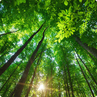
Between the two hills lies a vast plain - which we won't go so far as to call a valley. Largely urbanized (especially the closer you get to the capital), it is made up of silts and numerous sediments, which played a major agricultural role until the early 20th century. Stretching between Ermont / Eaubonne / Sannois and Pierrelaye, it rises to an altitude of around 50 meters. Few rivers cross the plain, but the Ru de Liesse (also known simply as the Liesse), a small tributary of the Oise, has its source in Pierrelaye. The area is not only agricultural, but also largely covered in forest, like the other hills, and was the setting for a unique project that changed the geography of the area: the creation of a new forest. Thus, in 5 communes of the Val Parisis conurbation (Bessancourt, Frépillon, Herblay-sur-Seine, Pierrelaye and Taverny), as well as in the communes of Méry-sur-Oise and Saint-Ouen-l'Aumône, a huge forest was created by man. Called the Maubuisson forest, it will eventually include no less than a million trees, returning the area to its original vocation. The project has a number of objectives: to combat global warming, promote the development of local biodiversity and combat atmospheric pollution. In concrete terms, the afforestation of this part of the plain is spread over a ten-year period, until the end of the current decade, and it is estimated that the forest will be mature in 30 to 50 years.
An oceanic climate
Although we're a good hundred kilometers from the sea here, the climate is nonetheless subject to oceanic influences. As a result, while the temperature differences between day and night, and between summer and winter, are greater than on the Normandy or Picardy coasts, they remain measured. In summer, the average temperature is around 25°C in the middle of the day, while the normal winter temperature is around 7°C. Frost is not uncommon, and snow may appear for a few days. While urban density is high, especially in the eastern part of the Val Parisis conurbation, it has nothing in common with the hypercentre of Paris. The advantage is that the heat wave felt in the streets of Paris during certain heatwaves is less intense in the agglomeration: here, people don't suffocate, and the hills of Parisis and Montmorency, as well as the Seine, provide welcome coolness during the heatwaves. Last but not least, rainfall is logically more abundant in winter: this is where it's at!